Doctoral defence in Earth Sciences - Muhammad Aufaristama
Veröld - Hús Vigdísar
023
The defence will be closed for audience but will be streamed live at https://www.youtube.com/user/HIvarp/live
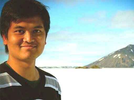
Ph.D. student: Muhammad Aufaristama
Dissertation title: The 2014–2015 lava flow field at Holuhraun: Deriving physical properties of the lava using multi remote sensing techniques and datasets
Opponents: Dr. Chris Hecker, Assistant Professor in Geological Remote Sensing, University of Twente, The Netherlands.
Dr. Catherine Neish, Assistant Professor in Planetary Surface, The University of Western Ontario, Canada.
Advisor: Dr. Ármann Höskuldsson, Research scientist at the Institute of Earth Sciences University of Iceland
Doctoral committee: Dr. Magnús Örn Úlfarsson, Professor at the Faculty of Electrical and Computer Engineering, University of Iceland.
Dr.Ingibjörg Jónsdóttir, Associate Professor at the Faculty of Earth Sciences, University of Iceland.
Dr. Þorvaldur Þórðarson, Professor at the Faculty of Earth Sciences, University of Iceland,
Chair of Ceremony: Dr. Magnús Tumi Guðmundsson, Professor and the Head of the Faculty of Earth Sciences, University of Iceland.
Abstract:
The purpose of this thesis is to employ remote sensing to study lava flow products during the 2014-2015 eruption at Holuhraun, Iceland. Multimodal remote sensing techniques and datasets were applied and developed for three studies (1) deriving thermal properties from satellite infrared remote sensing, (2) differentiating lava surface using airborne hyperspectral remote sensing, and (3) quantifying lava surface roughness from elevation model acquired by airborne LiDAR.
In the first study, we present a new approach based on infrared satellite images to derive thermal properties within the lava field during eruption and then compare the results with field measurement during the 2014-2015 Eruption at Holuhraun. We develop a new spectral index for Landsat 8, named the thermal eruption index (TEI), based on the SWIR and TIR bands (bands 6 and 10). The purpose of the TEI consists mainly of two parts: (i) as a threshold for differentiating between different thermal domains; and (ii) to apply dual-band technique to determine the subpixel temperature (Th) of the lava. Lava surface roughness effects are accounted for by using the Hurst coefficient (H), which is estimated from radar backscattering. A high H (smooth surface) indicates thinner crust meanwhile a low H (rough surface) indicates thicker crust and lower radiant flux. The total radiant flux peak is underestimated compared to other studies, although the trend shows good agreement with both field observation and other studies.
In the second study, we focus on retrieving the lava surface types contributing to the signal recorded by airborne hyperspectral at the very top surface of the 2014-2015 Holuhraun lava field. For this purpose, an airborne hyperspectral image acquired at Holuhraun with an AisaFENIX sensor onboard a NERC (Natural Environment Research Council Airborne Research Facility) campaign. For sub-pixel analysis, we used the sequential maximum angle convex cone (SMACC) algorithm to identify the spectral image endmembers while the linear spectral mixture analysis (LSMA) method was employed to retrieve the abundances. SMACC and LSMA methods offer a fast selection for volcanic product segregation. However, ground-truthing of spectra is recommended for future work.
In the third study, we perform both the topographic position index (TPI) and one-dimensional Hurst Exponent to derived lava flow unit roughness on the 2014-2015 lava field at Holuhraun using both airborne LiDAR and photogrammetry topography datasets. The roughness assessment was acquired from four lava flow features: (1) spiny lava, (2) lava pond, (3) rubbly pahoehoe lava, and (4) inflated channel. The TPI patterns on spiny lava and inflated channels show that the intermediate TPI values correspond to a small slope indicating a flat and smooth surface. Lava pond is characterized by low to high TPI values and forms a wave-like pattern. Meanwhile, irregular transitions patterns from low to high TPI values indicate a rough surface that is found in blocky lava and flow margins. The surface roughness of these lava features falls within the H range of 0.30 ± 0.05 to 0.76 ± 0.04. The roughest surface is the blocky, and inflated lava flows appear to be the smoothest surface among these four lava units. In general, the Hurst exponent values in the 2014-2015 lava field at Holuhraun has a strong tendency in 0.5, which has good agreement with early study for geological surface roughness.
Overall, this project provides an important application of remote sensing methods in real-time monitoring of lava flow. The development the techniques will be useful for future events.
About the doctoral candidate:
Muhammad Aufaristama was born and raised in In Indonesia.
He finished bachelor’s degree in physics-geophysics at the Universitas Padjadjaran, Indonesia.
He completed a joint master’s degree in Earth Observation Science from the University of Iceland and University of Twente, the Netherlands. During his masters studies Muhammad was a GEM grant holder and his studies were also funded by Indonesia Endowment fund for Education.
He started his PhD study in July 2016 at the University of Iceland.
During his PhD, Aufaristama has been partially supported by grants from Futurvolc, Vetools, Eurovolc, EVE, Vinir Vatnajökuls, Ofanflóðasjóður and the Indonesia Endowment fund for Education.
Muhammad Aufaristama