

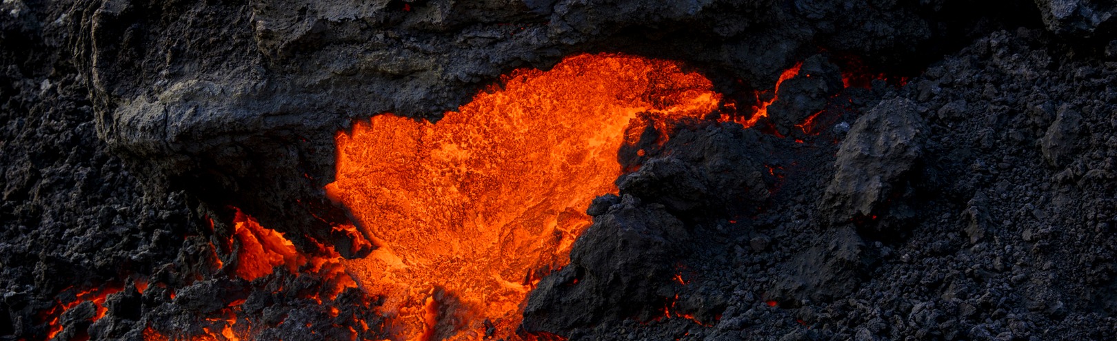
When the volcanic eruption at Fagradalsfjall on the Reykjanes peninsula began just over a year ago, people naturally starting thinking about the risk of the lava reaching nearby towns and infrastructure, which would have caused significant damage and had a serious impact on human lives and the economy. Various action was taken in an attempt to direct the lava flow along a certain path, preventing it from flowing across the road Suðurstrandarvegur. This action was based in part on lava flow models developed by scientists at the University of Iceland in collaboration with colleagues at the Icelandic Meteorological Office and around the world.
Coordinating this work developing better lava flow models is Gro Birkefeldt Møller Pedersen, a research specialist at the University of Iceland Institute of Earth Sciences. Her research career has focused on using remote sensing data to gain a better understanding of how lava behaves, making it possible to respond faster and more effectively to the hazards of an effusive eruption. Remote sensing involves taking digital images, often from a great height – from a plane or a satellite – and processing them ways that yield a wealth of information about environmental changes on Earth.
From Mars to Iceland
Gro was born in Denmark and completed a PhD in earth sciences from Aarhus University in 2011. Her doctoral thesis focused on landforms in the Elysium volcanic province on Mars. "My research interests are about using remote sensing data to find out more about the patterns of volcanic landscapes in order to understand what information we can extract regarding eruption dynamics and landscape evolution. The end goal is to use this information to forecast the future development of the landscape, for example the pathways of future lava flows," she explains.
"Overall my research concentrates on understanding volcanic landscapes, their formation, evolution and degradation. This ranges from investigating landscapes dominated by ice-volcano interactions on Mars to studying individual lava fields in Iceland. My aim is to better understand geological history and eruption dynamics, but also to more accurately forecast future hazards. My current project focuses in on how we can improve monitoring and forecasting of lava fields," adds Gro.
The goal is to forecast hazards more efficiently
Many populated areas are exposed to the threat of lava flows, which have caused casualties and considerable economic damage worldwide, Gro explains, giving examples of eruptions such as Kilauea in Hawaii, Etna in Sicily, Nyiragongo in the Democratic Republic of the Congo, Fogo in Cape Verde and of course Heimaey.
"Up to this point, forecasting of lava flow hazards has been only moderately successful. This is partly due to our incomplete understanding of how to simulate lava flows, and partly because of time-consuming monitoring techniques that hinder fast implementation of observations into hazard models at volcano observatories. I want to improve our success in this area," says Gro, who has also worked as a researcher in Denmark and Hawaii, but has been employed at the University of Iceland since finishing her PhD.
From the beginnig of the eruption at Fagradalsfjall. Gro hopes that the results of this project will benefit the geoscientific community and the stakeholders responsible for lava hazard forecasting and risk mitigation in future eruptions. "These benefits should include improved methods for lava flow monitoring and lava flow simulation, delivering better lava flow forecasting."
Interdisciplinary collaboration is key
The University of Iceland's new strategy, UI26, places a great deal of emphasis on interdisciplinary collaboration and international research partnerships. Both are key to this research project, where people from different fields have joined forces to improve our knowledge and understanding of lava flows.
"Our collaborators are leading specialists in their fields, including scientists from the University of Iceland's Faculty of Earth Sciences and Faculty of Electrical and Computer Engineering, the University of Hull in the UK, the Technion in Israel, and the University of Salzburg's Department of Geoinformatics in Austria. All these people are specialists in remote sensing and advanced image signal processing. We also collaborate with the Icelandic Meteorological Office, who are certainly stakeholders in this area because they will be the end-users of the monitoring and lava flow simulation techniques we are developing. Finally, we are working closely with the National Institute of Geophysics and Volcanology in Italy, who are contributing as renowned experts within the field of lava flows and lava flow simulation," explains Gro.
Many lessons learned from the Fagradalsfjall eruption
The University of Iceland has been working together with the Icelandic Meteorological Office for decades to develop lava flow models. Such models were first used for the Holuhraun eruption in 2014-2015, which was much larger than the eruption at Fagradalsfjall. But it was last year's eruption that saw significant advances in the use of lava flow models, as well as remote sensing data.
"Remote sensing data is essential during volcanic unrest in order to monitor the eruption dynamics. However, with many gigabytes of data, automated analysis is essential to extract important information, some of which will be input parameters or layers in numerical models that simulate lava flows," explains Gro.
She says that scientists learned a lot from the Fagradalsfjall eruption. "Both in terms of techniques and workflows that proved very efficient, but also in terms of where to focus and improve techniques and models for the next effusive eruption. We need to be able to collect data, interpret it and run models within a short time frame, so that results can be delivered during a volcanic crisis," says Gro.
She hopes that the results of this project will benefit the geoscientific community and the stakeholders responsible for lava hazard forecasting and risk mitigation in future eruptions. "These benefits should include improved methods for lava flow monitoring and lava flow simulation, delivering better lava flow forecasting."
You can find out more about the work of Gro Birkefeldt Møller Pedersen on her website.