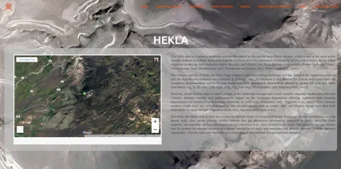
An interdisciplinary group of research scientists and students at the University of Iceland has in recent years developed methods to survey automatically changes in Icelandic nature with focus on one of the most active volcano in the country, Hekla. The group organised the Hekla, Öræfajökull and Remote Sensing Conference that took place at the University of Iceland last Friday, introducing the results of the project.
The project, „Environmental Mapping and Monitoring of Iceland by Remote Sensing (EMMIRS)“ received an excellence grant from the Iceland Research Fund in 2015. Numerous students and staff from the Faculty of Electrical and Computer Engineering; the Institute of Earth Sciences; the Faculty of Earth Sciences, and the Faculty of Life and Environmental Sciences at the University of Iceland have taken part in the project in addition to international and domestic collaborators. The specialisation of the participants lies in the field of remote sensing, digital image analysis, learning machines, geology, earth sciences, and environment and natural resources.
The spark for the project are the rapid and vast changes that can occur in Icelandic terrain, which can either be due to natural phenomena such as eruptions, earthquakes or ablation or human behaviour. In order to evaluate these changes and react it is vital to employ fast and reliable analytical procedures.
"The main goal of the project is to develop and implement methods for automated change detection allowing monitoring of geological and ecological changes in Iceland. In order to achieve this we use so-called remote sensing images taken from aeroplanes or satellites on different wavebands from which we extract a variety of information on the earth surface," says Jón Atli Benediktsson, rector of the University of Iceland, project leader and main applicant for the excellence grant. The technological revolution in the field of remote sensing enables researchers to acquire an enormous database for extensive periods of time. The aim of the project is thus to bring Iceland to the forefront in the field by connecting advanced information processing and mapping of Icelandic environment.